Rajnandgaon, a district nestled in the heart of Chhattisgarh, India, is a place steeped in history, culture, and natural beauty. In this article, we will embark on a journey through Rajnandgaon district, uncovering its rich past, vibrant present, and promising future. Join us as we answer ten popular questions about this captivating region.
1. What is the History of Rajnandgaon District?
Rajnandgaon district, like much of Chhattisgarh, has a history that stretches back millennia. In ancient times, it was a part of Dakshina Kosala and found itself under the influence of the Mauryan Empire during the time of Ashoka. Coins from the Indo-Sassanians discovered near Rajnandgaon dating back to the 3rd century CE indicate indirect contact with the rest of the world.
The region witnessed the rise and fall of various dynasties. In the 4th century CE, it was subdued by Samudra Gupta during his southern expedition. However, it’s important to note that while Gupta coins were found in Dakshina Kosala, it’s unlikely that the Guptas directly controlled this territory. Instead, local rulers acknowledged Gupta overlordship.
During different periods, parts of the region were controlled by the Nalas of Bastar and the Vakatakas. In the 6th century CE, the area came under the control of the Somavamshis, but it later fell back into Nala hands in the 7th century.
The 10th century CE saw the return of the Somavamshis to power, only to be overthrown by the Kalachuris, who claimed Haihaiya origin. The subsequent centuries witnessed the rise and fall of various chieftains, including those from Kanker and the Kalachuris or Haihaiyavansis. The northern part of the district was ruled by the Raj Gonds of Garha-Mandla.
The Mughals came into the picture after the struggle of Rani Durgavati. The rulers of Rajnandgaon, as well as the Kalachuris of Raipur, who ruled the southern part of the district, became vassals of the Mughals.
In 1742, the Marathas, led by the Bhonsles of Napur, invaded Chhattisgarh. This led to the quick overthrow of the last king of the Haihaiyavansis, and the Marathas took control of what is now Rajnandgaon district. Subsequently, the Bhonsles of Nagpur confiscated all the territory that is now Chhattisgarh, and it was given to Raghoji’s son, Bimbaji, who ruled it virtually independently.
British control of the region began after the Third Anglo-Maratha War. In 1818, Dongargarh revolted against the British but was quickly suppressed. The territory was returned to Maratha hands after the British balanced the accounts of the Marathas. It wasn’t until 1853 that Nagpur was annexed by the British under the Doctrine of Lapse, and Rajnandgaon fell under direct British administration.
The 20th century brought significant changes. In 1906, Thakur Pyarelal Singh promoted the Swadeshi movement in the district, and he played a crucial role in organizing mill workers in Rajnandgaon during a successful 34-day strike after the passage of the Rowlatt Act.
Rajnandgaon remained a Princely State in independent India until 1948 when it was merged into the Durg District of Madhya Bharat, later Madhya Pradesh. On 26 January 1973, Rajnandgaon district was carved out from the erstwhile Durg district. Subsequently, Kabirdham district was created from this district on 1 July 1998.
2. What is the Geography of Rajnandgaon District?
Rajnandgaon district is a land of diverse geography. Covering an area of 8,222 square kilometers, it shares borders with Kabirdham district to the north, Bemetara, Durg, and Balod districts to the east, Kanker district to the south, and Balaghat district of Madhya Pradesh, as well as Gondia and Gadchiroli districts of Maharashtra to the west.
The landscape of the district can be broadly categorized into different regions:
Chhattisgarh Plain: Most of the district falls within the Chhattisgarh plain, which comprises two watersheds—the Wainganga in the west and the Mahanadi in the east. The Shivnath River, a major tributary of the Mahanadi, originates in the district and flows through the central plain into Durg district.
Maikal Hills: In the northwest, bordering Balaghat and Kabirdham districts, lie the Maikal Hills. These hills are the eastern extension of the Satpuras and add a distinct topographical feature to the region.
Bastar Plateau: In the far south of the district, you’ll find the northernmost extension of the Bastar Plateau. This area is characterized by its unique terrain and thick forest cover, which has been largely preserved compared to the rest of the district. The plateau is sparsely populated and home to a significant tribal population.
3. What is the Demography of Rajnandgaon District?
Understanding the demographics of Rajnandgaon district provides insight into the people who call this place home. According to the 2011 census, the district had a total population of 1,537,133, making it roughly equivalent to the nation of Gabon or the U.S. state of Hawaii.
The district boasts a population density of 191 inhabitants per square kilometer, and it witnessed a population growth rate of 19.82% over the decade from 2001 to 2011. In terms of gender ratio, Rajnandgaon has a sex ratio of 1017 females for every 1000 males, indicating a balanced gender distribution.
When it comes to literacy, the district boasts a rate of 76.97%, reflecting a commitment to education among its residents. After the bifurcation of the district, there were 884,742 people, out of which 219,688 (24.83%) lived in urban areas. Scheduled Castes and Scheduled Tribes make up a significant portion of the population, with 10.83% and 19.75%, respectively.
The major Scheduled Castes in the district include Chamar and Mahar, constituting 91% of the Scheduled Castes population. As for the Scheduled Tribes, the primary communities are the Gonds, Kawar, and Halba, making up 97% of the total Scheduled Tribes population.
4. What Languages Are Spoken in Rajnandgaon District?
Language is a crucial aspect of any region’s culture and identity. In Rajnandgaon district, a diverse linguistic landscape adds to the richness of its heritage. As of the 2011 Census of India, the following languages were spoken in the district:
Chhattisgarhi (82.37%): Chhattisgarhi is the most widely spoken language in the district, reflecting the cultural and linguistic heritage of the region.
Hindi (13.26%): Hindi, as one of India’s official languages, has a significant presence in Rajnandgaon district and is used for communication and administration.
Marathi (1.73%): Marathi is also spoken by a small but notable portion of the population, reflecting historical and cultural ties.
Others (2.64%): Besides the dominant languages mentioned above, there are other languages spoken by minority communities, contributing to the linguistic diversity of the district.
5. What are the Major Religions Practiced in Rajnandgaon District?
Religion plays a vital role in the lives of the people of Rajnandgaon district. According to the 2011 census, the religious composition of the district is as follows:
Hinduism (93.80%): Hinduism is the predominant religion in Rajnandgaon district, with the majority of the population adhering to its various traditions and practices.
Buddhism (2.06%): Buddhism, with its roots in ancient India, has a presence in the district, representing a smaller religious community.
Islam (1.89%): Islam is practiced by a minority of the population, contributing to the religious diversity of the region.
Other (tribal religion) (0.73%): Some communities in the district follow tribal or indigenous religions, which are an integral part of their cultural identity.
Other or not stated (0.52%): This category includes individuals who either follow religions not covered in the above categories or choose not to state their religious affiliation.
The religious plurality in Rajnandgaon district is a testament to the coexistence of various faiths and belief systems among its residents.
6. What are the Notable Tourist Destinations in Rajnandgaon District?
Rajnandgaon district isn’t just a place of historical and cultural significance; it also boasts several captivating tourist destinations. Here are some notable places to visit in the district:
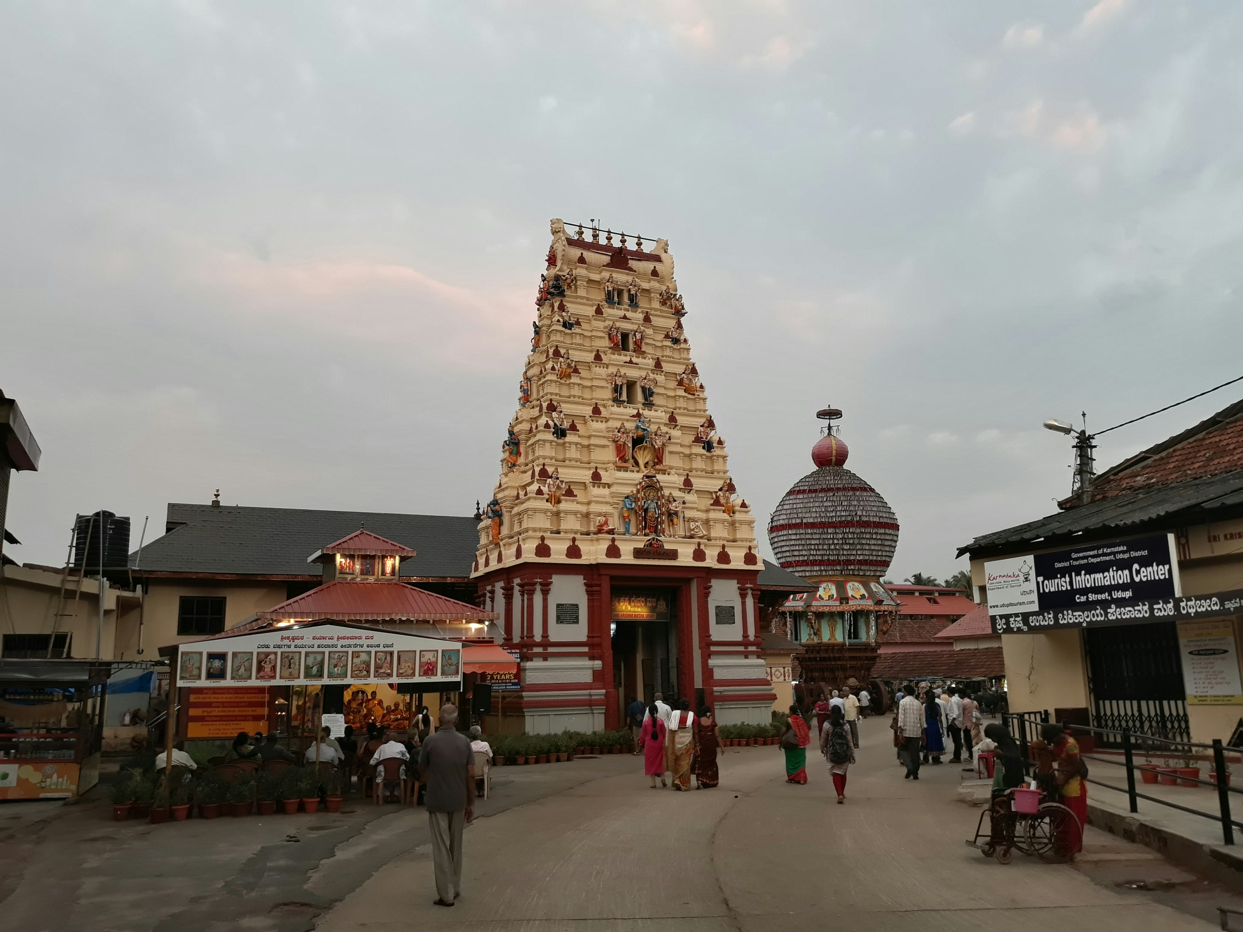
Dongargarh: A tehsil headquarters, Dongargarh is the main tourist and pilgrimage site of the district. The famous temple of Goddess Bamleshwari, perched on a hilltop at an elevation of 1,600 feet, is a must-visit. It is known as Badi Bamleshwari and draws hundreds of thousands of pilgrims during the navratris of Kavar and Chaitra.
Mata Sheetala Devi Shakti Peetha: An ancient temple dating back 2,200 years, this site is located 1.5 km from the railway station. The temple has a rich historical and religious significance.
Pragyagiri: This famous Buddhist Vihara is another attraction in the district. It offers visitors a glimpse into the region’s Buddhist heritage and spirituality.
Barfani Dham: Located in Rajnandgaon town, Barfani Dham is a popular place of pilgrimage visited by many devotees. It holds cultural and religious significance for the local community.
Ambagarh Chowki, Ambagarh Devi Mandir, Mongara Dem, Sankar Dahara Tipagarh Pahadi: These are among the other places of interest and natural beauty in Rajnandgaon district, each offering a unique experience to visitors.
Rajnandgaon district’s tourist destinations combine spirituality, history, and natural beauty, making it a diverse and appealing travel destination.
In conclusion, Rajnandgaon district in Chhattisgarh, India, is a region that seamlessly blends its historical and cultural heritage with its natural beauty. From its ancient history to its diverse demographics and tourist attractions, this district offers a glimpse into the multifaceted tapestry of India. Whether you’re interested in history, spirituality, or simply exploring the beauty of nature, Rajnandgaon has something to offer every traveler.a